Sharm :
Port Map Description Berths Equipments Contacts
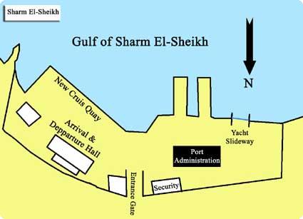
Port Map
Longitude
34o 17' E
Time Zone
GMT +2
VHF
12 16
B.A. Chart No
2375
Adm. Med. Pilot
NP 64
Latitude
27o 51.2' N
Max. Dft.
8 m.
Description
Location: Sharm El-Sheikh port is 360 km. distanced from Suez Governorate, and 490 km. from Cairo. It is located on top of the triangle of Sinai Peninsula, at the confluent of Suez and Aqaba bays at South Sinai Governorate Port Specifications
Engineering Features
Total Port Area 183500 sq. m.
Total Area opposing yacht berth 3500sq.m.
Total Yards Area 48000 sq. m.
Pilotage is compulsory. Pilots aboard vessels at the inner edge of the entrance channel. The port
provides VHF and radar controlled pilotage.
Berths
Detailed Berths Information:
Berth Number
Length (m.)
Depth (m.)
Number of Bollards
Passenger
1
625
8
5
Military purpose
Marine scaffold
90
4
-
Emergency scaffold
90
4
-
Equipments
Floating Units and Stevedoring Equipment
Type of Equipment
Quantity
Pilotage craft (205)
1
Service boat
2
Contacts
Address Sharm El-Sheikh Port, South Sinai
Telephone 069-660557 - 660217
Fax 069-660209