Arish :
Port Map Description Specifications Navigation Berths Contacts
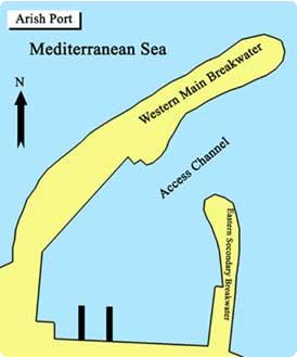
Port Map
Port ID Number (ISPS Code)
0057
Approval Date
16 September 2004
Latitude
31° 09' N
Longitude
033° 49' E
Time Zone
GMT +2
Description
Location: El-Arish port is the only Mediterranean port at the north of Sinai. Until 1983, it was merely a fishing vessel berth lacking the least of facilities. Since 1987, developments were made to protect the port seawards, and to adapt it for fishing activities as well as cargo traffic and transits, crop exportation and different maritime sports.
Port Characteristics:
Weather Mild
Raining Season Winter
Tidal range and flow 0.15 - 0.65m.
Specifications
Engineering Features
Total Area 202342.82 sq. m.
Water Area 161874.26 sq. m.
Land Area 40468.56 sq. m
Total Yards Area 30000 sq. m.
Maximum Port Length 2500 m
Maximum Port Width 80 m.
Productivity Features
Max. Ship Size 7.6 m. draft, and 10000 GRT vessels
Working Hours 24 h. (scheduled time)
Navigation
Entrance and Exit Strait 270 m. length, 100 m. width, 9-11 m. depth
Approach Area:
El-Arish lighthouse 37 m. high
Visibility 18 miles
Pilotage:
Two Senior pilots undertake pilotage works
Berths
Detailed Berths Information
Berth Number
Length (m.)
Depth
(m.)
Breadth
(m.)
Year of Construction
Number of Bollards
General Cargo
1
242
7-8
10
1984
10
2
122
3-4
5
1984
5
Contacts
Port Said Port Authority
Address North Sinai Governorate, Abu Sakl
Telephone +2068-320045
Fax +2068-322431